EarthScope national seismic monitoring project arrives in Upstate New York
A Syracuse University Earth scientist is coordinating placement of 25 seismic stations

EDITOR’S NOTE: Members of the media are invited to meet and observe SU’s science team in the field performing the scouting tasks required for installation of the monitoring stations during the week of June 24, 2012. Please contact Judy Holmes for further information.
Upstate New York is about to become part of EarthScope, the largest science project on the planet. Robert Moucha, a geophysicist in the Department of Earth Sciences in Syracuse University’s College of Arts and Sciences, is in charge of scouting locations for the placement of 25 earthquake-recording stations in a grid pattern from the Hudson Valley to the western New York State border, and from the St. Lawrence Seaway to the Poconos in Northern Pennsylvania.
The sites Moucha’s team is identifying over the next two months are part of the nearly 200 seismic-monitoring sites to be identified this summer in New England, the Mid-Atlantic, North and South Carolina, and Quebec, Canada. Helping Moucha are two undergraduate students—Peter Nelson, physics and Earth sciences major in SU’s College of Arts and Sciences, and Catherine Lambert, geology and English major from the University of Rochester.
EarthScope, a program of the National Science Foundation (NSF), deploys thousands of seismic, GPS, and other geophysical instruments to study the structure and evolution of the North American continent and the processes that cause earthquakes and volcanic eruptions. The first array of seismometers (Transportable Array) was installed along the Pacific coast in 2004. The seismic stations remain in position for about two years before being moved in a regular grid pattern (about every 40 miles or 70 km apart) across the United States. In 2014, the Transportable Array will head to Alaska.

EarthScope provided Moucha’s team with a map depicting the general areas in which monitoring stations are slated for installation. The students use Google Earth and other resources to locate an exact location for the monitoring station and identify the landowner. The students then travel to the site, talk with the landowner, and gain permission to locate a station on the site. Fieldwork includes establishing the site’s GPS coordinates; measuring it; checking it for drainage, soil, ground conditions, and accessibility for work crews; and determining its suitability for installation of technologies used to power the stations and allow for data transmission.
“Stations are powered by solar panels,” Moucha explains. “Too much shade will prevent the panels from generating the electricity needed to power the instruments. Similarly, data is transmitted via cellphone towers or satellite. The site needs to be in an area accessible to these signals.”
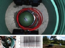
The students, who are paid a stipend for their work, generate a written site report for EarthScope. A construction crew is then dispatched to prepare the site for installation of the scientific equipment. An eight-foot hole needs to be dug for the seismometer. A science team installs the seismometer, solar panels, and communications equipment. Once the equipment is installed, landowners can go online to see in real time the data their seismometer is recording.
Moucha is working on a proposal to “adopt” one of the monitoring stations and convert it into a permanent station after the Transportable Array moves on to Alaska. The “Adopt a Station” program is offered through the NSF and USArray. Moucha and collaborators at the University of Rochester and Cornell University are also working on a joint geophysics field course that will be offered to students from all three universities this fall.
Media Contact
Judy Holmes
